Crossing the Sierra on the Way to the Pacific
Headed west through Truckee, California, the road starts climbing as you approach Donner Pass. For thousands of years Indians used this route to journey from the inland plains to the Pacific coast. Today we see their legacy in petroglyphs on the flat hard granite just below the summit. These carvings are thought to be two to three thousand years old, but no one really knows.
Some symbols are suggestive, but their precise meaning isn’t known either. The marks are cut on a gently sloping stone plain. I've got a separate essay on them here, if you are curious.
 |
| Petroglyphs are visible beyond this marker at Donner Summit |

In 1844 the Stephens-Townsend-Murphy party followed the old Indian trail past present-day Donner Lake and over the pass, becoming the first settlers to use the route. In the fall of 1846 the ill-fated Donner party tried to do the same, but early snows blocked them at Donner Lake. Half the group starved and the survivors resorted to cannibalism, giving the lake and pass the name it’s known by today.
 |
| Donner Lake seen from the pass. The Central Pacific (now UP) rail line clings to the slope on the right |
Over the next 20 years thousands of settlers used Donner Pass to reach the promised lands of California. The granite was rough and unforgiving, forcing settlers to dismantle their wagons and haul them over rocks, with many losing their belongings and even limbs or lives in the process.
When talk of a transcontinental rail link materialized, the route was surveyed through Donner Pass. Trains need a constant gentle slope, without up and down, so the route they chose was a bit south of the footpath and wagon road. The two paths do remain in sight of each other across the pass. The trail goes up and down over terrain to follow the most direct route. The rail line is cut at a constant angle into the sides of the mountains, clinging to them like a pasted-on stripe.
In the spring of 1868 the Central Pacific Railroad completed the laying of track over the pass. It took a crew of mostly Chinese laborers five years to cross the mountains, with numerous tunnels and cuts. The longest is tunnel #6, at 1,659 feet.

These tunnels were dug entirely by hand, with some assistance from draft animals and explosives. Thousands of laborers died in the building of the line, with most unknown today. The rough hacked appearance of the tunnels make a sharp contrast to the finished highway tunnels we pass through today.


Even at the height of summer tunnel 6 is dark and cold. Light barely penetrates the quarter-mile to the center; the photos above were made with the help of some scattered sunlight, my own miner's headlamp, and a Leica M10 camera at ISO 50,000 - almost seeing in the dark.
The shorter tunnels are not as cold, but there is still an eerie feeling inside them. It's easy to imagine the ghosts of the Chinese laborers, and the many railroaders who lost their lives on this pass.
The builders of the railroad also built a wagon road to bring up workers and supplies from Truckee. In 1914 that construction road was rebuilt as the Lincoln Highway, the nation’s first transcontinental auto road. Vestiges of the Lincoln Highway are visible through the pass today, including this overpass that carried the road under the rail grade before the summit tunnel. Compared to overpasses today this one looks tiny, but the biggest thing that went under it back then was a Ford Model T.

In the photo above a mother and child stand in front of a Lincoln Highway underpass. This road has vanished today but portions still carry modern data cables as evidenced by the yellow warning post.


Railroad engineers had assumed they could keep the rail line open through winter storms by running plows back and forth. They did not foresee the amount of snow that would fall. Donner pass usually sees thirty feet of snow, and sometimes twice that. Snow lingers on the mountainside well into summer. Not only did the snow bury the lines, avalanches swept the threads of track into the valleys below, sometimes taking trains and passengers with them.
The answer was snow sheds, miles of structures that protected the tracks from snow and hopefully allowed avalanches to pass over harmlessly. By the early 20thcentury the original wood snow sheds had been replaced with concrete, anchored to the mountainside with heavy steel rods and girders.
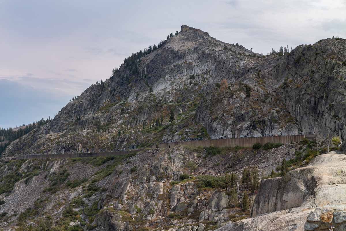
In many places the railroad appears to cling to sheer cliffs, and inside the snowsheds that is evident with rock wall on one side and concrete on the other.

The image above shows a snow shed from outside. The image below is the same shed, inside. Light streams in through the slits in the walls, which are enough to give weak illumination without filling the shed with snow.

Outside the concrete is a few feet of flat ground and then a drop of one thousand feet or more into the valley. The rail line climbs to 7,100 feet at the top of the pass. The edge is visible in the photo below:

Another interesting feature is the Chinese wall, so named for the laborers who built it, with stone alone. This structure carries the rail line across a dip in the contours. There is no mortar in the main embankment, which carried increasingly heavy train traffic for 100+ years. There is post-construction mortar in the upper retaining wall; both are impressive examples of stonework. They are built from granite cut for the tunnel bores.

This retaining wall held back winter avalanches and supported massive freight trains for 130 years, just as the original Chinese stone masons built it.

This is the hiking trail down from the Chinese wall. This is probably not much different from the path the Indians and original emigrants trod:

Here is another filled embankment. You can see a snow shed entrance at the upper right. The slope is all fill, carrying the railroad over the low spot. Huge amounts of fill were required in areas like this to prevent being washed out in floods or avalanches.

In this next two images you can see a smaller rock wall. This is a built up section of the construction service road, which later became the Lincoln Highway for early motorcars.


This view looks up at the Chinese walls. The trees give a sense of scale

In 1993 the Union Pacific abandoned the six mile section at the top of Donner Pass in favor of a newer three mile tunnel through adjacent Mt. Judah that carries the rails under the worst of the summit conditions. The photo below looks west, shortly after the rails emerge from the Mt. Judah tunnel:


Since then the abandoned tunnels have become a destination for hikers. They are also a destination for urban artists, few of whom braved the threats of trains and railroad police before the tracks were taken up. The tunnels today have an eerie feel, even looking in from outside.


The tunnels are filled with graffiti:


This image shows how massive the tunnel construction has to be, to survive the onslaught of winter snow and slides:

A shaft of sunlight streams in through an opening in the wall. The people in the image give a sense of scale. Look at the size of the concrete columns that reinforce the roof. That is necessary in areas that may be hit with avalanches. Why the height, you ask? In olden days the tunnels needed to be tall to hold and diffuse the steam locomotive smoke. Today they need height to accommodate double stack containers, such as these cars headed west through Truckee:

If you want to see this for yourself take the Donner Pass Road west from Truckee. There are exits for the road on I-80. Climb to the overlook bridge parking area and walk across the road and downhill a few hundred yards to the trail up to the petroglyphs. From there the trail goes up to the Chinese walls between two of the tunnels. Tunnel six will be on your right, to the west.
The images in this essay were taken with a Leica M10 camera and a Leica 28 2.8 lens. All images were shot hand held at shutter speeds ranging from 1/500 to 1/2 second. The rangefinder system has an advantage focusing in the dark, compared to more automated cameras where focus would tend to hunt or be wrong. The M10 finally gives Leica a body whose sensor really performs to the level set by cameras like the Nikon D5 SLR. Leica lenses have always been superlative, and their manual nature forces the photographer to think more before each shot.
I certainly could have taken these shots with a D5, but doing so would have required a tripod and it would have been a much bigger production to get it up there. Smaller point and shoot camera could not have delivered the results of the M10 in the tunnels, though they would have been competitive outside. Photographers always have to trade quality against size and portability.
When photographing landscapes like these I like the slow reflective nature of the Leica camera, combined with the top-shelf image quality.
(c) 2018 John Elder Robison


The tunnels are filled with graffiti:

In the photo below I am walking through a snow shed, which transitions to a tunnel a short distance ahead. The light at the end is the sun illuminating the exit, and not an oncoming locomotive.

More graffiti:


This image shows how massive the tunnel construction has to be, to survive the onslaught of winter snow and slides:

A shaft of sunlight streams in through an opening in the wall. The people in the image give a sense of scale. Look at the size of the concrete columns that reinforce the roof. That is necessary in areas that may be hit with avalanches. Why the height, you ask? In olden days the tunnels needed to be tall to hold and diffuse the steam locomotive smoke. Today they need height to accommodate double stack containers, such as these cars headed west through Truckee:

If you want to see this for yourself take the Donner Pass Road west from Truckee. There are exits for the road on I-80. Climb to the overlook bridge parking area and walk across the road and downhill a few hundred yards to the trail up to the petroglyphs. From there the trail goes up to the Chinese walls between two of the tunnels. Tunnel six will be on your right, to the west.
The images in this essay were taken with a Leica M10 camera and a Leica 28 2.8 lens. All images were shot hand held at shutter speeds ranging from 1/500 to 1/2 second. The rangefinder system has an advantage focusing in the dark, compared to more automated cameras where focus would tend to hunt or be wrong. The M10 finally gives Leica a body whose sensor really performs to the level set by cameras like the Nikon D5 SLR. Leica lenses have always been superlative, and their manual nature forces the photographer to think more before each shot.
I certainly could have taken these shots with a D5, but doing so would have required a tripod and it would have been a much bigger production to get it up there. Smaller point and shoot camera could not have delivered the results of the M10 in the tunnels, though they would have been competitive outside. Photographers always have to trade quality against size and portability.
When photographing landscapes like these I like the slow reflective nature of the Leica camera, combined with the top-shelf image quality.
(c) 2018 John Elder Robison

.jpeg)


Comments